Understanding Your Rates
Each year, Council is required to adopt a Revenue Policy that sets out its Income and Expenditure for the coming Financial Year. As part of its Revenue Policy, Council sets its fees and charges for the various services it provides.
The Blayney Shire Rates Calculator can be downloaded and used to estimate rates & charges as set-out in the annual Operational Plan.
The downloadable Excel Spreadsheet can be used to estimate individual rates and charges based upon your Property Valuation, Rating Category, Services provided (waste and sewerage) and whether or not a Pensioner Rebate is applicable.
Click here to download the Rates Calculator for 2025-26
- To use the Rates Calculator, it will be necessary to enter the Land Value of your property in the first column of the spreadsheet ( under 'Your Land Valuation'). The Land Value for your property can be found by referring to your Rates Notice or VG Notice of Valuation.
- The Rating Category for your property should be selected from the first drop down box (Ordinary Rates)
- The appropriate option in each of the remaining drop-down boxes should be selected, based upon services provided and whether or not a Pension Rebate is applicable.
Certain rating categories or services provided (commercial sewer connection) will not be able to be calculated using the Rates Calculator and Council should be contacted by phone 02 6368 2104 or online for a rates estimate.
Rating Categorisation and Sub-Categorisation
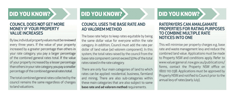
Each piece of land in the Blayney Shire is assigned a category and these categories are used to determine what rates need to be paid. The Local Government Act has four main categories of rating which apply in Blayney Shire:
- Residential
- Farmland
- Mining
- Business
In addition, under Section 529(1) of the Local Government Act, Council also has the following sub-categories that sit within the above categories:
- Residential
- Residential - Blayney & Carcoar
- Residential – Millthorpe
- Business
- Business - Blayney Millthorpe & Carcoar
- Mining
- Mining - Gold and Copper
- Mining Gold
The maps accessible from this page show the different categories of land across our Shire. The rates for each of these are based on the land value set by the State Valuer General and multiplied by the rate in the dollar for that particular category of land.
Should you not agree with the categorisation of your land you may lodge an Application for change in category of land to request an amendment.
Rate Category Mapping
Under Section 405 of the Local Government Act, Council must have for inspection at its office a map that shows the parts of its area to which each category, and sub-category, of the ordinary rate and each special rate included in the draft operational plan applied during a period of public exhibition.
These maps are available from Council’s Administration Office at 91 Adelaide Street, Blayney.
The series covers most of the Blayney LGA, subject to data availability.
Zoning Information
Zoning Classification is different to your rate category. For further information regarding your zone under the Council's current Local Environmental Plan (LEP), please contact Council's Environmental Services Department.
Please Note: the processes involved in generating this product have been fully automated and as a result, some information may be omitted or poorly presented. Where possible, the database is being amended to improve the final presentation.
Cadastral boundaries shown are the legal representation, not the physical. No liability will be accepted for any inaccuracy in the information depicted.
Land Values and Council Rates
The Valuer General has published a fact sheet for councils about land values and council rates.
Fact Sheet - Land Value System
The fact sheet will help you understand the valuation system. It also includes the Valuer General's contact details for landholders to access more information or ask questions.
Last modified:
27 Nov 2025